-
 Welcome to plumtriA platform for Research & Innovation
 -
 Looking for Funding?Check out the current open calls
 -
 Register today to start receiving our monthly newsletter
 -
 Looking to partner up?Search our list of registered profiles
 -
 You have questions on a particular funding programme?
Project Bee-Optech4Honey - Mapping a More Sustainable Future for Maltese Thyme Honey
Image

Honey production in Malta plays out on a small island with a tightly mixed landscape. Beekeepers work across fields, garrigue and settlements that sit close together, yet they are expected to deliver a product with a clear representation of the place, and one of these is Maltese wild thyme honey. The main challenge lies in making sure that the bees forage mainly from the flowers of wild thyme in such a tightly-knit landscape.
Drones and artificial intelligence make that challenge surmountable. Drone surveys and machine learning can convert thousands of overlapping images into maps that show thyme cover and thyme’s potential competitors. This study asks whether Malta can realistically and sustainably support monofloral wild thyme honey (honey made mostly from thyme nectar), and if so, where. By combining drone surveys, multispectral imaging, GIS and supervised machine learning, the team searched for thyme-exclusive conditions during the early dry-summer window (end of May to early July). Focusing on the Mellieħa-Manikata area, the analysis identified an approximately 8-kilometre zone where thyme appeared to be the dominant flowering species during bloom.
Biological and geographic constraints on mono floral honey
Honey bees respond to nectar rewards, not to human labels such as "thyme honey". Most foraging occurs within a few kilometres of the hive, yet bees can travel to around 4.5 kilometres and sometimes approach 5 kilometres. In Malta, a circle of that size usually crosses multiple habitat types and land uses. Even where thyme dominates, other nectar sources can occur along field margins, gardens or disturbed ground, creating naturally multifloral honeys.
This means the true botanical origin of honey depends on spatial context: it is not enough to have thyme near the hive; competing melliferous plants must be absent, or negligible, within reach during the key weeks of nectar flow. Field walks rarely cover an entire foraging radius at fine detail, and flowering can change quickly. Drone mapping and AI classification close that gap by surveying large areas rapidly and classifying flowering resources consistently across the whole map.
Research collaboration and study objectives
The work was developed through collaboration between the Biodiversity and Ecology Research Group (BERG) at the University of Malta and the Intelligent Agriculture and Livestock Applications Laboratory (Intala Lab) at Isik University in Turkiye, within a wider effort to apply ICT tools to apiculture. The partnership combined local ecological knowledge with expertise in sensing, analytics and applied machine learning. This was done though the project known as ‘Bee-Optech4Honey’, funded by Xjenza Malta and TUBITAK.

The Maltese objective was straightforward: determine whether any area could support monofloral Maltese wild thyme honey based on the spatial availability of nectar sources across a bee's foraging range. The team aimed to produce decision-ready outputs that can inform hive placement and support monofloral labelling.
Methods overview: Drone surveys, multispectral imaging, and GIS analysis
Surveys were flown in June, when Maltese wild thyme is in bloom and produces a strong visual and spectral signal. Mapping during bloom improves separability for both human interpretation and machine learning, and it increases the chance of detecting any competing melliferous blooms that could influence honey during the same period.
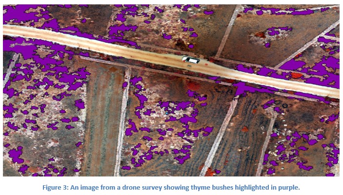
A drone equipped with a DJI Mavic 3 Multispectral camera captured imagery in visible and infrared bands (DJI, Mavic 3 Multispectral specifications). Multispectral data add diagnostic information beyond standard RGB photographs because plants and flowers reflect light differently across wavelengths. The imagery was processed using photogrammetry to produce georeferenced orthomosaics and digital elevation models (DEMs), creating a map-like surface where each pixel is tied to coordinates.

Supervised machine learning was used to map thyme distribution. Labelled examples of flowering thyme were used to train a deep learning classifier to recognise thyme-specific spectral and textural patterns, and the model was applied across the orthomosaic to generate a classified thyme layer. GIS analyses then evaluated whether alternative melliferous resources occurred within bee-relevant distances, translating classification into forage-zone evidence.
Key findings: A unique thyme-only zone in Mellieħa
The drone-AI pipeline produced a result with direct operational value. In the Mellieħa-Manikata region, classification outputs indicated an approximately 8-kilometre zone where Maltese wild thyme was detected as the only melliferous flowering species during the survey window. Other vegetation occurred, but competing nectar-producing blooms were not observed within that mapped area for that period.
The key feature is scale and continuity. A thyme-rich patch does not guarantee monofloral honey, but a thyme-only landscape large enough to contain a full foraging radius changes the odds decisively. If colonies are placed near the centre of the mapped zone, a typical foraging radius of up to around 4.5 kilometres, and even the upper bound near 5 kilometres, can remain largely inside a landscape where bees have no alternative nectar to choose during bloom. The result is a strong ecological basis for monofloral honey grounded in mapped forage availability.
Implications for honey provenance and certification
Strong provenance claims link a product to the environment that produced it. Laboratory analysis can characterise honey after harvest, but it does not always show what resources were available to the bees while nectar was being collected. Drone and AI mapping fills that gap by documenting the forage landscape within reach of a colony at the relevant time.
In practical terms, the thyme-only zone functions like a natural provenance envelope. When colonies are placed centrally and managed during the thyme flowering period, the monofloral claim can be supported by an evidence chain: timed drone surveys, georeferenced orthomosaics, AI classification layers quantifying thyme cover, and GIS analyses demonstrating that the foraging circle sits inside a thyme-only landscape. This creates a transparent, repeatable record that can complement laboratory verification and strengthen certification discussions.
Land use considerations and policy relevance
The findings have a clear policy message: in this case, hive placement is critical. Colonies placed near the edge of the thyme-only zone can forage beyond it, increasing exposure to alternative nectar sources. Colonies placed nearer the centre keep the foraging radius within the mapped envelope, preserving the ecological conditions that favour monofloral production.
This creates an opportunity for evidence-based site designation. Instead of treating beekeeping sites as interchangeable, authorities can recognise that some locations have unique forage properties that directly influence product character. The drone-AI pipeline also offers a monitoring tool: repeat flights can confirm whether thyme-only conditions hold across seasons, rainfall variation or land-use changes, allowing guidelines to be updated with fresh evidence.
Broader significance for Malta's agricultural and cultural landscape
This work illustrates how modern sensing can support traditional products by making their ecological foundations visible. Maltese wild thyme honey has cultural meaning, and drone plus machine learning methods translate that meaning into spatial criteria that can be mapped, communicated and revisited.
The same approach is adaptable to other origin-linked foods and crop-pollinator systems: map resources at the right time, classify them with transparent models, and use GIS to connect maps to real foraging dynamics. For Malta, where space is limited and land-use pressure is high, targeted, data-led strategies can focus support on places where the ecological conditions genuinely favour monofloral production.
Conclusion: A data driven path to authentic Maltese thyme honey
The Mellieħa-Manikata study shows that monofloral Maltese wild thyme honey can be supported by spatial evidence. By surveying flowering resources using drone-borne multispectral imaging, processing imagery into orthomosaics and DEMs, and applying supervised machine learning within a GIS framework, the team identified an approximately 8-kilometre zone where Maltese wild thyme was the only melliferous flowering species detected during early summer.
Given known honey bee foraging distances, colonies placed centrally within this thyme-only zone would be expected to forage almost exclusively on thyme during bloom, providing a strong ecological basis for monofloral origin. For policymakers, the implication is practical: enabling controlled colony placement in this specific area is a targeted decision supported by a method that can be repeated over time to verify that forage conditions remain suitable.
Information and image source:
Author: Mark Mifsud
Editors: David Mifsud, Matthew Calleja
Attachments: